Newfoundland and Labrador, Canada’s easternmost province, experiences a winter season marked by significant variability in climate and weather conditions. This article explores the winter elements that shape life in this rugged and beautiful part of the world, delving into air temperatures, snowfall, freezing precipitation, snow depth, and wind speeds, and how these factors vary across the province.
Overview of Winter’s Variability in Newfoundland and Labrador
Winter in Newfoundland and Labrador is a season of contrasts. The province’s unique geography, spanning the island of Newfoundland and mainland Labrador, coupled with its position along the North Atlantic Ocean, results in a diverse range of winter weather conditions. From coastal areas that experience milder, wetter winters to inland regions where temperatures can plunge and snow accumulates deeply, the variability is profound.
Air Temperatures
During the winter months, air temperatures in Newfoundland and Labrador can vary significantly due to several factors. The province’s latitude and the influence of Arctic air masses play a crucial role in these variations. Generally, temperatures are colder in Labrador than on the island of Newfoundland, with coastal areas often benefiting from the moderating effects of the ocean.
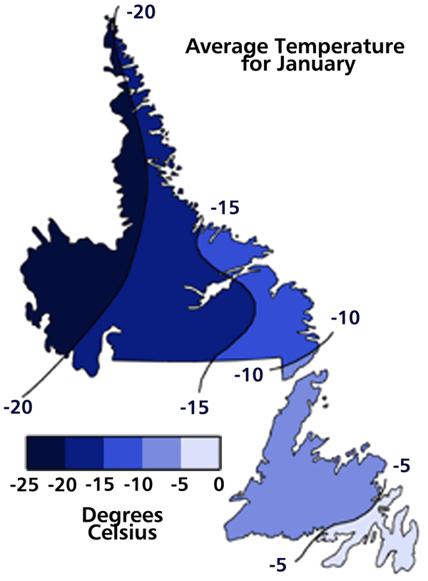
Image modified by Duleepa Wijayawardhana with permission, 1998. Reproduced by permission of Gary E. McManus and Clifford H. Wood, Atlas of Newfoundland and Labrador (St. John’s, NL: Breakwater, ©1991 MUNCL) Plate 6.5(a).
Factors Influencing Temperature Variations
One of the key factors influencing temperature variations is the formation of sea ice. As sea ice forms along the coast, it acts as an insulator, reducing the heat exchange between the ocean and the atmosphere. This can lead to colder temperatures in coastal regions. In contrast, areas further inland, especially those in Labrador, experience more extreme cold due to the lack of this moderating effect.
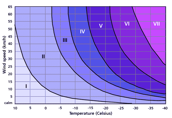
This index is used by the U.S. Air Force at Goose Bay Air Base, Labrador as a guide for outdoor activities during cold weather conditions.
Adapted by Duleepa Wijayawardhana, 1998. Courtesy of McGill-Queen’s University Press, Montreal, Quebec. From Hugh M. French and Olav Slamaker, eds., Canada’s Cold Environments. (Montreal: McGill-Queen’s University Press, ©1993) 9.
Specific Temperature Ranges and Records
In terms of specific temperature ranges, coastal areas such as St. John’s typically see average winter temperatures hovering around -1°C (30°F), while inland areas like Goose Bay in Labrador can experience average temperatures as low as -15°C (5°F). Record lows have been recorded in various parts of the province, with temperatures in Labrador occasionally plunging below -40°C (-40°F) during severe Arctic outbreaks.
Snowfall and Freezing Precipitation
Snowfall is a defining feature of winter in Newfoundland and Labrador. The types and frequency of snowfall, as well as other forms of freezing precipitation like sleet and freezing rain, vary widely across the province.
Types and Frequency of Snowfall
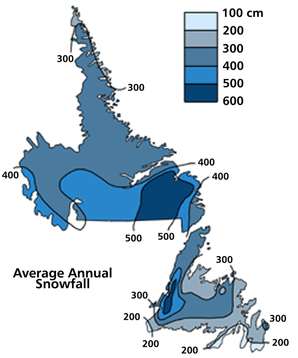
Snowfall in Newfoundland and Labrador ranges from light flurries to intense snowstorms driven by powerful Nor’easters. Coastal areas, particularly on the island of Newfoundland, can experience heavy snowfall due to the moisture-laden air masses that move in from the Atlantic Ocean. In contrast, Labrador, with its colder and drier air, often sees lighter, powdery snow.
Indicates amounts at lower elevation only.
Image modified by Duleepa Wijayawardhana with permission, 1998. Reproduced by permission of Gary E. McManus and Clifford H. Wood, Atlas of Newfoundland and Labrador (St. John’s, NL: Breakwater, ©1991 MUNCL)
Spatial Variation in Snowfall
There is significant spatial variation in snowfall across the province. For instance, Gander on the island receives an average of 400 cm (157 inches) of snow annually, whereas coastal Labrador, like the town of Nain, averages closer to 300 cm (118 inches). Inland areas in Labrador can experience even higher snowfall totals due to the influence of orographic lift as moist air is forced upward by the terrain.
Snow Depth
Snow depth is influenced by several factors, including the frequency of snowfall, temperature, and wind conditions. The accumulation of snow can vary dramatically across Newfoundland and Labrador.
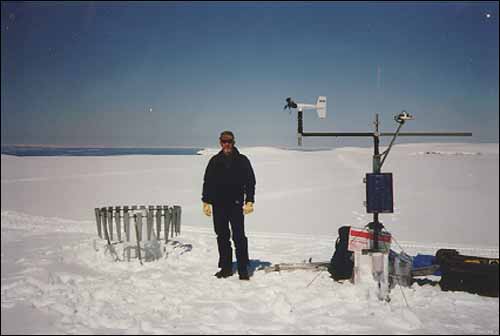
Summit climate station as viewed in late April 1997 (snow depth 1.7 m) – left and early August 1996 – below.
Reproduced by permission of Colin Banfield. Photo ©1998.
Factors Affecting Snow Depth
Temperature plays a crucial role in determining snow depth. Colder temperatures tend to preserve snow cover, leading to deeper accumulations over time. Wind can also impact snow depth by causing drifting and redistribution of snow.
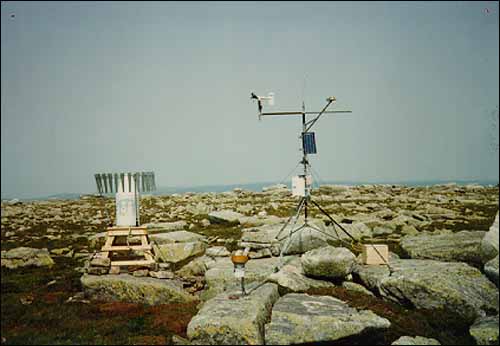
Amongst the instruments visible are the precipitation measurement gauge (with wind shield), wind sensor, solar radiation sensor, air temperature and humidity sensors (inside shield toward base of mast) and the solar power panel.
Reproduced by permission of Colin Banfield. Photo ©1998.
Regional Differences in Snow Accumulation
Regions like the Avalon Peninsula on the island of Newfoundland often have less snow depth compared to inland Labrador. In Goose Bay, for example, snow depths can reach over 100 cm (39 inches) during peak winter months, while coastal areas might see less accumulation due to milder temperatures and occasional thaws.
Wind Speeds
Strong winds are a common feature of winter in Newfoundland and Labrador, significantly influencing the chilling effect of air temperatures and the overall winter experience.
Influence of Strong Winds on the Chilling Effect
The combination of cold temperatures and high winds can lead to dangerously low windchill values. During Arctic air outbreaks, wind speeds can exceed 60 km/h (37 mph), driving windchill equivalent temperatures to extreme lows.
Regional Variations in Wind Speeds
Wind speeds vary across the province, with coastal areas often experiencing the highest winds due to their exposure to the open Atlantic. Inland areas, while also windy, generally see less extreme conditions.
Temperature/Wind-Chill Index
The Temperature/Wind-Chill Index is a critical tool used to assess the combined effects of cold temperatures and wind on human comfort and safety.
Explanation of the Temperature/Wind-Chill Index
Originally developed by the U.S. Air Force for use at Goose Bay Air Base, the Temperature/Wind-Chill Index has been adapted for local conditions in Newfoundland and Labrador. This index provides a measure of the perceived temperature, taking into account both the actual air temperature and the wind speed.
Adaptation of the Index for Local Conditions
In Newfoundland and Labrador, the index is used to issue warnings and advisories during extreme cold events, helping residents prepare for and respond to harsh winter weather.