The Historical Context of Navigation
During the Age of Discovery, roughly spanning from the early 15th century to the early 17th century, the world witnessed unprecedented maritime exploration. This era was driven by various factors, including economic ambitions, the quest for new trade routes, and the desire for territorial expansion. European nations, particularly Spain and Portugal, were at the forefront of this movement, seeking to establish direct access to the riches of Asia and the Americas.
Geographically, the vast oceans represented both a barrier and an opportunity. The Mediterranean Sea was already a hub of trade, but as demand for spices, silks, and precious metals grew, the need for new maritime pathways became apparent. The discovery of the Cape of Good Hope by Bartolomeu Dias in 1488 and Vasco da Gama’s subsequent voyage to India in 1498 exemplified the quest for new routes that would circumvent the overland trade monopolies controlled by Middle Eastern powers.
Culturally, the Renaissance inspired a revival of learning and curiosity about the world. Navigators and explorers were motivated not only by profit but also by a spirit of adventure and a desire to spread Christianity. Figures like Christopher Columbus and Ferdinand Magellan became emblematic of this era, their journeys fueled by a mix of ambition and the hope of discovering new lands.
The challenges of navigating uncharted waters were immense. Early explorers relied heavily on rudimentary instruments and their own observations of the stars. The need for more reliable navigation tools became increasingly clear as voyages extended further into the unknown. This led to the development and refinement of essential navigational instruments such as the astrolabe, which allowed mariners to measure the altitude of celestial bodies, and the compass, which provided a reliable means to determine direction.
According to historian John R. Hale, in his book Exploration: The Quest for the New World, “The development of navigational instruments was crucial for the success of long sea voyages, enabling explorers to traverse vast distances with greater confidence” (Hale, 2001). The establishment of trade routes and colonial empires fundamentally altered global trade dynamics, laying the groundwork for the interconnected world we know today.
In summary, the early days of exploration were marked by a confluence of geographical challenges, cultural aspirations, and the urgent need for effective navigation tools. These factors not only propelled the Age of Discovery but also shaped the future of maritime travel and trade.
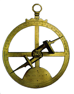
The Astrolabe: A Key Instrument for Celestial Navigation
The astrolabe, a remarkable tool that has stood the test of time, played a crucial role in the maritime navigation of early explorers. This ancient instrument, originating in the Hellenistic world around 150 BC, was refined by Islamic scholars during the Middle Ages and became a staple for navigators by the 15th century. Its design is a sophisticated combination of a flat disk and a rotating arm, known as an alidade, which allows users to measure the altitude of celestial bodies above the horizon.
Using the astrolabe, navigators could determine their latitude by measuring the angle of the sun at noon or the position of stars during the night. For instance, when sailors observed the North Star, Polaris, they could gauge their latitude in the Northern Hemisphere with remarkable accuracy. This capability was vital for explorers like Christopher Columbus and Ferdinand Magellan, who relied on the astrolabe to chart their courses across uncharted waters.
Design and Functionality
- Components: The astrolabe consists of several key parts: the mater (the main body), the tympan (a plate that displays the celestial coordinate system), and the rete (a framework that represents the stars).
- Measurement: To measure the altitude of a celestial body, the navigator would align the alidade with the star and read the angle on the scale. This angle could then be used to calculate latitude using trigonometric principles.
According to historian Donald Hill, the astrolabe was not just a navigational tool; it was also a symbol of the intellectual advancements of the era. In his book, The History of Navigation, Hill notes, The astrolabe epitomized the merging of science and exploration, allowing mariners to journey beyond the horizon with confidence.
Significance in Exploration
The astrolabe facilitated the Age of Exploration by enabling navigators to venture into previously unknown territories. It was instrumental in voyages such as Vasco da Gama’s journey to India in 1498, where he used the astrolabe to navigate the Indian Ocean. The ability to determine latitude accurately allowed European powers to expand their empires, establish trade routes, and enhance cultural exchanges.
As navigational techniques evolved, the astrolabe’s use diminished with the advent of more precise instruments like the sextant in the 18th century. However, its influence remains undeniable; the principles of celestial navigation it established laid the groundwork for modern navigation techniques.
In conclusion, the astrolabe was more than just a tool for measuring celestial angles; it was a gateway to exploration, empowering early navigators to traverse the vast oceans and contribute to the mapping of the world. Its legacy is a testament to human ingenuity and the relentless pursuit of knowledge in the face of the unknown.
The Quadrant: Navigating the Skies
The quadrant, an essential tool in the arsenal of early navigators, played a pivotal role in the advancement of maritime exploration. This instrument, primarily constructed of wood or brass, features a quarter circle arc marked with degrees and a sighting mechanism to measure the angle of celestial bodies, such as the sun or stars, above the horizon.
Dating back to the 15th century, the quadrant was largely popularized by navigators like Ferdinand Magellan and John Cabot, who utilized it to enhance their navigational capabilities during their explorations. The instrument allowed sailors to determine their latitude by measuring the altitude of a celestial body at a given time, a technique that was crucial for safe passage across uncharted waters.
Construction and Use
The typical quadrant consists of a quarter-circle arm, known as the ‘limb’, which is calibrated in degrees. The most common form, the sextant, evolved from the quadrant in the late 18th century, but the fundamental principles of celestial navigation remained the same. To use a quadrant, a navigator would:
- Hold the quadrant vertically, ensuring it is level.
- Look through the sighting hole at a celestial body.
- Adjust the movable arm until the body aligns with the graduated scale on the limb.
- Record the angle, which corresponds to the height of the celestial body above the horizon.
This process not only required a steady hand but also a keen understanding of celestial mechanics. The accuracy of the measurements was critical, as errors could lead to significant navigational mistakes.
Impact on Navigation
The introduction of the quadrant greatly improved the reliability of navigation at sea. Prior to its widespread use, mariners relied heavily on dead reckoning and rudimentary methods that often led to miscalculations. The quadrant allowed for a more scientific approach, facilitating voyages across the vast oceans and contributing to the Age of Discovery.
According to historian David Waters, the quadrant was revolutionary in that it allowed for a more precise understanding of ones position at sea, thus opening up new trade routes and exploration opportunities. This statement reflects the transformative impact of the quadrant, which was instrumental in the mapping of previously uncharted territories.
Conclusion
In summary, the quadrant not only served as a crucial navigational tool but also represented a significant leap forward in the art and science of navigation. By enabling more accurate measurements of celestial bodies, it paved the way for future innovations in navigation, ultimately shaping the course of maritime history.
The Magnetic Compass: Steering Through Uncharted Waters
The magnetic compass, a pivotal invention in the history of navigation, emerged around the 11th century in China. Its use spread to Europe by the late 13th century, fundamentally transforming maritime exploration. Unlike earlier navigation tools that relied heavily on celestial bodies, the compass offered a consistent and reliable means of determining direction, even in overcast conditions or during the night.
Before the compass became widely adopted, navigators faced the challenge of using celestial navigation, which depended on the position of the sun and stars. This method was not always reliable, particularly in regions where weather conditions often obscured these celestial bodies. The introduction of the compass allowed sailors to steer their vessels with greater confidence, facilitating longer and more ambitious voyages.
How the Compass Works
The compass operates on the principle of magnetism. A magnetized needle, balanced on a pivot point, aligns itself with the Earth’s magnetic field, pointing towards magnetic north. This simple yet ingenious mechanism enables navigators to determine their heading relative to the cardinal directions: north, south, east, and west.
Evolution of the Compass
Over the centuries, the compass underwent significant enhancements:
- Floating Compass (circa 1300): The floating compass was developed to improve stability and accuracy. It consisted of a magnetized needle floating in a liquid, allowing for more precise readings.
- Mariner’s Compass (16th century): This version featured a card that was marked with directions, making it easier for sailors to read their course at a glance.
- Gyrocompass (early 20th century): Unlike magnetic compasses, gyrocompasses use the principles of angular momentum to find true north. This innovation was crucial for modern navigation, especially for ships and aircraft.
Impact on Navigation and Exploration
The compass not only revolutionized navigation but also played a crucial role in the Age of Exploration. Navigators like Vasco da Gama and Christopher Columbus relied heavily on this instrument to chart unknown waters, leading to significant discoveries and the expansion of trade routes. According to historian Geoffrey Parker, “The compass was the key to the Age of Discovery, allowing European powers to explore and dominate vast territories across the globe.”
As navigational techniques advanced, the compass remained an essential tool for mariners. Its reliability provided a sense of security that encouraged exploration, ultimately leading to the comprehensive mapping of the world’s oceans and coastlines.
Conclusion
The magnetic compass is a testament to human ingenuity and the relentless pursuit of knowledge. Its evolution reflects the broader advancements in navigation technology and the enduring quest for exploration. Today, while modern technologies like GPS have largely supplanted traditional navigational tools, the compass remains a symbol of the maritime heritage that has shaped our understanding of the world.
Challenges Faced by Early Navigators
The journey of early navigators was fraught with numerous challenges that tested their skills and resilience. Navigating the vast and unpredictable oceans was no small feat, especially when many of these explorers ventured into waters that were largely uncharted. The following key challenges played a significant role in shaping the art of navigation:
- Unpredictable Weather: Mariners often faced fierce storms, sudden squalls, and rough seas that could turn a calm voyage into a perilous struggle for survival. For instance, the infamous hurricane season in the Caribbean posed substantial risks to explorers like Christopher Columbus during his voyages in the late 15th century.
- Vastness of Uncharted Waters: Early explorers sailed into vast oceans without accurate maps or knowledge of what lay ahead. The Pacific Ocean, for instance, was largely unexplored until the late 18th century, presenting a daunting challenge for navigators who relied on stars and rudimentary instruments to guide their way.
- Limited Knowledge of Geography: In the early days of exploration, the understanding of global geography was rudimentary at best. Many navigators had to rely on secondhand accounts and flawed maps. The work of cartographers like Gerardus Mercator in the 16th century began to improve geographical knowledge, but it took time for accurate maps to become widely available.
Accurate measurements of latitude and longitude were critical in overcoming these challenges. The development of tools such as the astrolabe and later the sextant allowed navigators to determine their position more reliably. The longitude problem, however, remained a significant hurdle until the invention of the marine chronometer by John Harrison in the 18th century, which enabled sailors to keep accurate time at sea and thus calculate their longitudinal position accurately.
The importance of these measurements cannot be understated. As the renowned historian and author Derek Hayes notes in his book, “Historical Atlas of the Pacific Northwest,” “the ability to determine one’s location with precision was a game-changer for explorers, allowing them to venture further into the unknown and return safely.” This advancement not only enhanced exploration but also facilitated trade routes and the eventual mapping of the world.
In summary, the early navigators faced a multitude of challenges that tested their ingenuity and determination. Their reliance on evolving navigational instruments and techniques laid the groundwork for future explorations and significantly contributed to our understanding of the world’s geography.
The Transition from Celestial Navigation to Advanced Techniques
The evolution of navigation during the Age of Exploration marked a significant turning point in maritime history, particularly with the transition from traditional celestial navigation to more advanced methods. Celestial navigation, which relied on the observation of celestial bodies like the sun, moon, and stars, was the primary means by which navigators determined their position at sea for centuries. However, this method was fraught with challenges, including the need for clear skies and extensive knowledge of astronomy.
One of the key advancements that revolutionized navigation was the sextant, developed in the mid-18th century. The sextant allowed sailors to measure the angle between a celestial body and the horizon with remarkable precision. Its design, which evolved from earlier tools like the astrolabe and the quadrant, provided navigators with a more accurate means of calculating their latitude. The use of sextants became widespread following its refinement by British instrument maker John Hadley in 1731, who is often credited with improving the design to enhance its usability at sea.
In conjunction with the sextant, the development of the marine chronometer in the 18th century played a crucial role in determining longitude. The chronometer, perfected by John Harrison in 1761, allowed sailors to keep precise time while at sea. This innovation was vital because knowing the exact time at a specific location enabled navigators to calculate their longitudinal position by comparing local time with Greenwich Mean Time (GMT). The significance of Harrison’s work cannot be overstated, as it solved the long-standing problem of determining longitude, which had eluded mariners for centuries.
| Instrument | Function | Key Innovator | Year of Advancement |
|---|---|---|---|
| Sextant | Measures angles of celestial bodies for latitude | John Hadley | 1731 |
| Marine Chronometer | Keeps precise time for determining longitude | John Harrison | 1761 |
The integration of these advanced tools marked a pivotal shift in navigation techniques. By the late 18th century, navigators could confidently traverse the oceans, significantly enhancing the safety and efficiency of maritime travel. The increased accuracy in determining both latitude and longitude not only facilitated exploration but also fostered the growth of global trade routes and the mapping of the world.
As navigational techniques continued to evolve, the ingenuity and resourcefulness of navigators were evident. The transition from celestial navigation to advanced techniques like the sextant and chronometer not only represented technological advancements but also a profound change in the way humanity interacted with the sea. As noted by historian David McCullough, “The sea is the world’s greatest highway, and the ability to navigate it has been essential to the development of civilizations” (McCullough, 2001).
In conclusion, the shift from traditional celestial navigation methods to advanced techniques was instrumental in shaping maritime exploration and trade. This evolution not only improved the accuracy of navigation but also laid the groundwork for the interconnected world we know today.
The Impact of Navigation Instruments on Exploration and Trade
The evolution of navigation instruments has profoundly influenced exploration and trade, enabling explorers to traverse previously uncharted waters and establish vital trade routes. The introduction of tools such as the astrolabe, compass, and quadrant marked significant milestones in maritime navigation, allowing navigators to make more accurate journeys across the globe.
One of the earliest and most notable instruments, the astrolabe, was developed by ancient Greeks and refined by Islamic scholars between the 8th and 15th centuries. This device allowed navigators to measure the altitude of celestial bodies, aiding in the determination of latitude. For instance, during the Age of Exploration, navigators like Ferdinand Magellan relied on the astrolabe to chart their course during his circumnavigation of the globe from 1519 to 1522.
Another crucial advancement was the magnetic compass, which gained widespread use in Europe by the late 14th century. The compass provided explorers with a reliable means of determining direction, especially when celestial bodies were obscured by clouds or landscapes. The compass was instrumental in the voyages of Christopher Columbus, whose expeditions from 1492 onward opened the Americas to European exploration and trade.
As trade expanded, the need for more precise navigation became evident. The quadrant, developed in the 15th century, allowed sailors to measure the angle of the sun or stars above the horizon, further refining their ability to determine latitude. This device proved essential for explorers like James Cook, who undertook significant voyages in the 18th century, mapping the Pacific and establishing British trade routes.
These navigation instruments not only facilitated exploration but also played a pivotal role in the establishment of trade networks. The ability to navigate accurately allowed for the expansion of maritime trade routes, linking Europe with Asia, Africa, and the Americas. For example, the Portuguese, using advanced navigational techniques, established a sea route to India in the late 15th century, which opened a lucrative trade in spices and other goods.
Moreover, the transition from celestial navigation to more advanced techniques, such as the use of the chronometer in the 18th century, further revolutionized maritime exploration. The chronometer, invented by John Harrison in 1761, allowed sailors to determine their longitude accurately, which was a significant challenge for navigators. This advancement enabled explorers to claim territories with greater confidence and facilitated the expansion of empires.
In conclusion, the development of navigation instruments was crucial in shaping the course of exploration and trade throughout history. These tools not only enhanced the accuracy of navigation but also enabled the establishment of global trade routes and colonial expansion, illustrating the ingenuity and resourcefulness of navigators who bravely ventured into the unknown.
The Mapping of the World: From Myth to Reality
The journey from mythical representations of the world to accurate cartographic depictions is a testament to the advancements in navigation tools and techniques. In ancient times, maps were often based on legend and conjecture rather than empirical evidence. For instance, the Tabula Rogeriana, created by the Arab geographer Muhammad al-Idrisi in 1154, was one of the first world maps that attempted to combine both myth and reality but still lacked precise navigational data.
With the advent of navigation instruments in the late Middle Ages and the Renaissance, explorers began to chart the world with increasing accuracy. The introduction of tools like the astrolabe and the quadrant allowed navigators to measure celestial bodies, enabling them to determine their latitude with remarkable precision. These instruments, alongside the magnetic compass, revolutionized maritime navigation and provided the necessary data for cartography.
One significant figure in this transition was Ferdinand Magellan, whose expedition from 1519 to 1522 was the first to circumnavigate the globe. Magellan’s journey underscored the importance of accurate measurements in navigation, as his crew relied on celestial navigation techniques to traverse vast and uncharted waters. His voyage produced maps that were more accurate than ever before, leading to a better understanding of the world’s geography.
The 16th century also saw the development of the Mercator projection, devised by the Flemish cartographer Gerardus Mercator in 1569. This innovative map projection represented lines of constant course, making navigation easier for mariners. The Mercator projection became a standard for nautical charts, influencing how the world was perceived and understood.
As the 17th and 18th centuries approached, navigational advancements continued with the invention of the sextant in the 1730s. This device allowed sailors to measure the angle between a celestial body and the horizon, providing a means to calculate their longitude with greater accuracy. Notably, the British Admiralty’s publication of the Nautical Almanac in 1767 further aided mariners by providing crucial astronomical data for navigation.
These developments marked a significant shift from the mythological to the empirical. As navigators began to rely on instruments and scientific methods, the world transitioned from being a mysterious, uncharted expanse to a mapped reality, leading to the Age of Exploration and the eventual establishment of trade routes that connected distant lands.
In conclusion, the evolution of navigation instruments played a pivotal role in the accurate mapping of the world. From ancient myths to precise cartographic representations, these advancements not only enhanced navigation but also transformed global exploration and trade, shaping the modern understanding of geography.
The Ingenuity and Resourcefulness of Navigators
The age of exploration, spanning from the 15th to the 17th centuries, was marked by remarkable creativity and problem-solving skills among navigators. These early mariners faced numerous challenges as they ventured into uncharted waters, yet their innovations in navigation practices laid the groundwork for modern techniques. This section highlights some of the key advancements and the brilliant minds behind them.
Innovative Tools and Techniques
Early navigators relied on a variety of instruments, each reflecting the ingenuity of its time. The following tools were crucial for exploration:
- Astrolabe: Developed during the Hellenistic period, the astrolabe was essential for measuring the altitude of celestial bodies. By the 15th century, it had been refined for maritime use, allowing navigators to determine their latitude with greater precision.
- Quadrant: This 90-degree arc device helped sailors measure the angle of stars above the horizon. Popularized in the 16th century, quadrants provided a simpler alternative to the astrolabe and were easier to use on a moving ship.
- Magnetic Compass: First introduced to Europe from China in the 12th century, the compass became indispensable by the late Middle Ages. Its ability to provide cardinal directions greatly improved navigators’ confidence in unknown waters.
Adapting to Challenges
As navigators ventured beyond the familiar coastlines, they encountered challenges such as unpredictable weather, varying ocean currents, and the vastness of the open sea. The ability to adapt was crucial. For instance, mariners developed the practice of dead reckoning, a method of estimating one’s current position based on a previously determined location, speed, and direction of travel. This technique was vital when celestial observations were not possible due to cloudy skies.
Moreover, the introduction of the log line in the 16th century allowed sailors to measure their speed through water, further enhancing their navigation capabilities. This simple yet effective tool consisted of a rope with knots tied at regular intervals, which was thrown overboard and allowed to drift for a specific time.
Legacy of Early Navigators
The contributions of early navigators extended beyond mere exploration. Their collective knowledge and innovative spirit paved the way for future advancements in navigation technology. Figures like Ferdinand Magellan and Vasco da Gama not only pushed the boundaries of known geography but also fostered a deeper understanding of the principles of navigation.
Their legacy is evident today in modern navigation systems, which, despite being vastly more sophisticated, still rely on the foundational concepts established by these early pioneers. As noted by historian David Abulafia, “The navigators of the Age of Discovery were not just explorers; they were scientists, mathematicians, and artists, whose contributions have shaped our understanding of the world” (Abulafia, 2011).
In conclusion, the ingenuity and resourcefulness of early navigators were crucial in overcoming the limitations of their time. Their innovations not only facilitated exploration and trade but also laid the groundwork for the complex navigation systems we rely on today.
- Navigation – History.com
- Navigational Instrument – Britannica
- How Navigators Use the Stars – National Geographic
- What is an Astrolabe? – Royal Academy
- The History of the Compass – The Mariners’ Museum
- The History of the Quadrant – Marine Insight
- Jeremiah Lee and the Art of Navigation – Science History Institute
- What is a Compass? – Natural History Museum
- Early Navigation Tools – United States History
- Celestial Navigation – National Geographic Society